


Phillips 3, Phillips County, Colorado
About
Outline
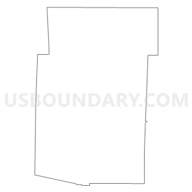
Summary
| Unique Area Identifier | 549049 |
| Name | Phillips 3 |
| County | Phillips County |
| State | Colorado |
| Area (square miles) | 79.33 |
| Land Area (square miles) | 79.33 |
| Water Area (square miles) | 0.00 |
| % of Land Area | 100.00 |
| % of Water Area | 0.00 |
| Latitude of the Internal Point | 40.66797160 |
| Longtitude of the Internal Point | -102.28671320 |
Maps


Graphs
Select a template below for downloading or customizing gragh for Phillips 3, Phillips County, Colorado


Neighbors
Neighoring Voting District (by Name) Neighboring Voting District on the Map
- Phillips 1, Phillips County, CO
- Phillips 2, Phillips County, CO
- Phillips 4, Phillips County, CO
- Phillips 5, Phillips County, CO
- Phillips 8, Phillips County, CO
- Sedgwick 2, Sedgwick County, CO
- Sedgwick 3, Sedgwick County, CO